
Brief Explanation of Zoning and Development Permits in Vancouver
Zoning enables the development of land in the city by encouraging compatible land uses and buildings. Zoning regulations reflect City Council policies based on community goals for the future of the city and its neighbourhoods.
The city is divided into many zoning districts, each of which permits a variety of land uses. Some zoning districts are scattered across the city, while others are found only in a single neighbourhood. The regulations in each district control land use and the site area, height, bulk, floor area and design of buildings. They also set site coverage, building depth, building setbacks from legal property lines and external design.
In each district some uses are permitted “outright” (as of legal right); however, most are “conditional” and subject to the special consideration of the Director of Planning or the Development Permit Board. Some regulations may be varied or relaxed, usually within certain limits. Conditions of use, limits or relaxations are usually stated in the by-laws; however, they can be decided by the Director of Planning or the Development Permit Board.
Development Permit Process
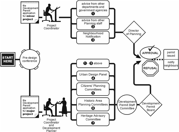
Minor Applications: A minor application is for a development that is already “outright” under the existing zoning, or is not considered to be contentious. Examples include one- and two-family dwellings or additions, and simple changes of use. Most minor applications are reviewed and decided by designated staff, on behalf of the Director of Planning.
Major Applications: A major application is for a development that may have a significant impact on its surroundings, or may be contentious in the community. This could be due to its location, scale and overall context. Examples include buildings such as a high-rise or a residential building in the downtown area. Most major development applications are reviewed and decided by the Development Permit Board; although, the Board (when considering a Preliminary application) can delegate the final decision on the complete application to the Director of Planning.
Permit Issuance: If a development application is approved, a development permit is issued once all conditions of approval are achieved. In some instances, requested land uses may receive a development permit which limits the use for a specific time period (e.g., 6 months, 1 year, etc.)
Permit Refusal: If a development application is refused, or any of the conditions of approval are disputed, an applicant may file an appeal to the Board of Variance. Submissions to the Board must be made no later than 30 days from the date the decision is made on the development application.
Public Notification: Neighbours are notified of development applications for conditional uses and requested relaxations of zoning regulations where the proposed development could affect such things as privacy, views and shadowing. Neighbours are always notified of major development applications to be dealt with by the Development Permit Board as well as other applications known or expected to be contentious.
Notification may occur by mailing out letters to the community, requiring the applicant to post signs on the site, or a combination of both methods. Those notified are given about 2 weeks to submit any comments. When the decision is made on the development application, those who responded to the notification are renotified and advised of the decision.
Development Permit Staff Committee (DPSC): This is an inter-departmental City staff committee which reviews all major development applications and then makes recommendations to the Development Permit Board. DPSC meetings are not open to the public or applicants.
Development Permit Board (DPB): Board members are the Director of Development Services(Chair), the Director of Planning, the General Manager of Engineering Services, and the Deputy City Manager, or their designated alternates. The Chair is a non-voting member. The Board makes all decisions; however, it receives advice from an Advisory Panel consisting of eight members appointed by City Council. Of the eight members, two are representatives of the development industry, two are representatives of the design professions, and four are representatives of the general public. The Board meets every second Monday and meetings are open to the public.
Board of Variance and Parking Variance Board: This is an appeal body, independent of City Hall, that hears and then decides upon appeals regarding decisions related to development permits, zoning regulations, signs and parking matters. The Board meets every second Wednesday of the month and meetings are open to the public.
Frequently Used Terms
Development: Any change in the use of any land or building, including the carrying out of any construction, engineering or the operations, in, on, over or under land or land covered by water.
Development Permit: This gives permission to use or develop property under the City’s zoning regulations.
Minor Amendment: If a development permit is issued and remains valid, an applicant may seek to change or modify certain aspects of the proposal. If the requested change(s) is of a minor nature, the Director of Planning may waive the requirement for a new development application, and process the modifications as a minor amendment to the previously issued development permit.
Building Permit: This gives permission to carry out development as approved by a development permit or where a development permit is not required, or to demolish, excavate or carry out most new construction, alterations and renovations of existing buildings.
Outright Uses: These are uses that are permitted “as of right” under the existing zoning and a development permit will be issued on the basis that the development application satisfies all other related City by-laws, policies and guidelines.
Conditional Uses: These are uses that may be permitted but require approval of the Director of Planning or the Development Permit Board. Such uses (e.g., a church in a residential area) would also be reviewed with regard to the applicable regulations and provisions of the by-laws and the approving authority would also have regard for the intent of the by-laws, any plans, policies or guidelines approved for the area, the recommendations of any advisory groups for the area, and the responses of adjacent neighbours who may be notified.
Relaxations: The City’s Zoning and Development By-law and Parking By-law allow for limited relaxations of certain regulations. Usually relaxations would be considered in the case of site specific hardships arising from site peculiarities, such as irregularly shaped lots, or steeply sloping sites, where it may be difficult to comply with the regulations. However, in some areas of the city, the zoning regulations include the potential for increased building floor area, height, or building size, where certain guidelines are met, or where social or community goals are achieved. Decisions on these requests may be made by the Director of Planning, the Development Permit Board, or designated staff members, provided consideration is given to all City Council approved policies and guidelines. In most cases, the review process for applicants requesting relaxation of regulations will include a notification of those neighbouring property owners considered to be directly affected.
Floor Space Ratio (FSR): Often called “density”, FSR is the primary way to control the size of buildings, and the maximum FSR permitted in different zones varies across the city. FSR is the number obtained by dividing the floor area of a building by its site area, noting that there are floor areas that must be included, as well as floor areas that may be excluded in the overall calculation. Exclusions are generally intended to promote liveability and good building design.
Building Height: Height limitations vary depending on where the proposed development is located in the city. Regulations limit the height that a building can rise above an artificial surface created by joining official established building grades at all corners of a site. In addition to regulating height, some zones contain a building envelope that limits upper floors to preserve views and reduce overshadowing.
Official Established Building Grade: The intended elevations of the street or lane along the property line of the site related to City datum, as established by the City Engineer.
Site Area and Site Coverage: In some zones, certain uses are required to have a specified minimum site size. Site area is also used to determine such things as the allowable floor space (see FSR). Site coverage (expressed as a 2percentage) determines how much of the land area can actually be covered by a building.
[top]